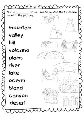
Label Landforms Worksheet
Are you a geography enthusiast or a teacher in search of engaging and informative resources to teach students about landforms? Look no further! In this label landforms worksheet, we have carefully curated a collection of visually appealing diagrams and descriptions that will help students develop a clear understanding of various landforms and their characteristics. Whether you're an educator looking to supplement your lesson plans or a student eager to expand your knowledge, this worksheet is designed to captivate your interest and deepen your understanding of the subject.
Table of Images 👆
More Other Worksheets
Kindergarten Worksheet My RoomSpanish Verb Worksheets
Healthy Eating Plate Printable Worksheet
Cooking Vocabulary Worksheet
My Shadow Worksheet
Large Printable Blank Pyramid Worksheet
Relationship Circles Worksheet
DNA Code Worksheet
Meiosis Worksheet Answer Key
Rosa Parks Worksheet Grade 1
What is a landform?
A landform is a natural feature of the Earth's surface, such as mountains, valleys, plateaus, plains, canyons, and coastlines, that are created by geological processes like erosion, deposition, and tectonic plate movements. Landforms play a crucial role in shaping the physical environment of the Earth and impacting various natural processes and human activities.
What are some examples of mountains?
Some examples of mountains include Mount Everest in Asia, Denali (formerly known as Mount McKinley) in North America, Mount Kilimanjaro in Africa, and the Matterhorn in Europe.
What is a valley?
A valley is a low area of land that is usually located between hills or mountains. Valleys are often formed by the natural erosion caused by rivers or glaciers, and they typically have a river running through them. Valleys can vary in size, shape, and depth, and they are often known for their scenic beauty and rich agricultural land.
What is a plateau?
A plateau is a flat-topped area of high ground, often found on mountains or elevated landforms, that is characterized by relatively level terrain after a steep ascent. Plateaus are usually formed by geological processes such as tectonic uplift, volcanic activity, or erosion, and they can be large or small in size. Plateaus are important geographical features that have significant impacts on local climates, ecosystems, and land use.
Describe a canyon.
A canyon is a deep, narrow valley with steep sides, often carved by a river or erosion over time. It typically features rugged terrain, dramatic cliffs, and stunning rock formations, offering breathtaking views and unique geological formations. Canyons can vary in size and shape, ranging from the massive Grand Canyon in the United States to smaller, more intimate canyons found around the world, each with its own distinct beauty and charm.
What is a peninsula?
A peninsula is a landform that is surrounded by water on three sides, typically connected to a larger landmass by a narrow strip of land. Peninsulas often have coastlines that provide abundant opportunities for maritime activities and are characterized by their unique geography, with a mix of both land and water features.
How would you describe a lake?
A lake is a large body of water surrounded by land, characterized by stillness and tranquility. It serves as a habitat for various aquatic species and provides recreational opportunities for activities such as swimming, boating, and fishing. Lakes can vary in size from small ponds to vast expanses of water, and their beauty is often enhanced by the reflection of the sky and surrounding landscape on their surface.
What is an island?
An island is a landmass that is completely surrounded by water, usually smaller than a continent and not connected to any larger landmass. Islands can be formed through volcanic activity, erosion, or the rising and falling of sea levels. They come in various sizes and shapes, and are often valued for their natural beauty, unique ecosystems, and recreational opportunities.
Explain what a river is.
A river is a large flowing body of water that typically moves in a single direction, such as from higher ground to lower ground. Rivers are formed by precipitation and runoff, and they play a crucial role in shaping the landscape, providing habitats for wildlife, and serving as sources of water for irrigation, drinking, and transportation for human civilizations. Rivers also contribute to the water cycle by carrying nutrients and sediments downstream, ultimately leading to the ocean.
What is a desert and how would you describe it?
A desert is a barren, arid region characterized by sparse vegetation, little to no precipitation, and extreme temperatures. It typically consists of vast stretches of sandy or rocky terrain with minimal water sources. Deserts exhibit unique ecosystems adapted to the harsh environment, often hosting specialized plant and animal species that have evolved to conserve water and withstand high temperatures. The stark and desolate landscapes of deserts showcase an unforgiving beauty that can be both challenging and awe-inspiring.
Have something to share?
Who is Worksheeto?
At Worksheeto, we are committed to delivering an extensive and varied portfolio of superior quality worksheets, designed to address the educational demands of students, educators, and parents.







Comments